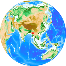
M 7.7 -Myanmar Earthquake on March 28, 2025
Uploaded on April 1, 2025
Information in our site
- Abstract Database
- Tun, Pa Pa, Shibazaki, Bunichiro, and Hurukawa, Nobuo (2009). Hypocenter relocation and moment tensor analysis of earthquakes in Myanmar: Toward the investigation of the Burma subduction-Sagaing fault system. Bulletin of IISEE, 43, 25-30.
- Maung Maung, Phyo, Shibazaki, Bunichiro, and Hurukawa, Nobuo (2010). Relocation of earthquakes in Myanmar by MJHD method: Aftershocks of large earthquakes and seismicity along the Sgaing fault. Bulletin of IISEE, 44, 25-30.
- Nyi Nyi Zaw, and Tani, Masanori (2013). Seismic evaluation and retrofit of existing reinforced concrete buildings. Bulletin of IISEE, 47, 97-102.
- Way Phyo Linn, and Tajiri, Seitaro (2014). Modified seismic evaluation method for reinforced concrete buildings in Myanmar. Bulletin of IISEE, 48, 73-78.
- Ngun Za Iang, and Kita, Saeko (2019). Completeness Magnitude of Earthquakes and b-Value in Myanmar. Synopsis of IISEE-GRIPS master report.
- Nwet Nwet Yi, and Azuhata, Tatsuya (2020). Seismic evaluation and retrofitting of existing reinforced concrete buildings in Myanmar. Synopsis of IISEE-individual study report.
Direct links
- Hurukawa, Nobuo, Tun, Pa Pa, and Shibazaki, Bunichiro (2012). Detailed geometry of the subducting Indian Plate beneath the Burma Plate and subcrustal seismicity in the Burma Plate derived from joint hypocenter relocation. Earth, Planets Space, 64, 333-343.
-
M 7.7 - 2025 Mandalay, Burma (Myanmar) Earthquake USGS Earthquake Hazards Program
- Myanmar National Building Code 2020
Related institutions
The Generic Mapping Tools (GMT, Wessel and Smith, Eos, 79, 579, 1998) was used to make the figure of the epicenter.
The epicenter is from the USGS. The land topography and ocean bathymetry are from ETOPO1 (doi:10.7289/V5C8276M).
©2025, International Institute of Seismology and Earthquake Engineering (IISEE)

